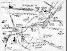
 This is the first orginal map of Dupont. Dupont was orginally Smithville,
Heildelberg, and Lidyville as seen from this map. Once incorporated, the area became the Borough of Dupont.
This is the first orginal map of Dupont. Dupont was orginally Smithville,
Heildelberg, and Lidyville as seen from this map. Once incorporated, the area became the Borough of Dupont.
This is the first orginal map of Dupont. Dupont was orginally Smithville,
Heildelberg, and Lidyville as seen from this map. Once incorporated, the area became the Borough of Dupont.
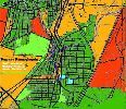
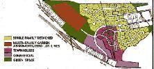
This is a street map of Dupont, showing the zoning of the borough.
The white rectangle with the red dot shows where the borough building, police station, and road crew maintenance
garage is located. The other white smaller areas show the locations of where the seven council members live, as well as
the mayor. The aqua marine color denotes the two parks contained within the borough.